


QK-A051T WiFi AIS Transponder
$690.92
Class B AIS Transponder all boat types.
- 2 x NMEA outputs for chart plotter/s or multiplexer/s of your choice.
- USB output
- WiFi output
- Straight forward USB setup
Description
Quark-elec’s A051T Class B AIS Transponder is the ideal solution to transmit your ship’s information, including; location, name, course, speed etc..
The ideal transponder to fulfil your local Class B legal requirements, as well as for peace of mind and project tracking,
This is the ideal, compact AIS transponder.
In addition to transmitting your AIS information to local boats and receiving stations, the A051T will also decode incoming AIS messages.
The A051T will receive and decode your GPS location as well as the AIS messages from local ships. Combining the AIS and GPS data, you will be able to view which other boats and ships are around and your position compared to them and the coastline.
You can view your AIS and GPS data on
- up to two chart plotters
- your laptop, computer or tablet through USB OTG(Android or Linux compatible)
- up to 4 WiFi enabled devices
Straight forward setup.
Features:
- Transmission of vessels own position, speed and heading etc. to other vessels and receiving stations within VHF range
- Receives and processes GPS and all AIS message types
- A method of monitoring the position, speed and heading of other AIS vessels within VHF range
- The ability to plot the progress and changes in heading/speed of other AIS vessels within VHF range on a PC, chart plotter or wireless device.
- AIS Transmitter ‘Standby’ facility to conserve power, or for privacy.
- Low-cost anti-collision / monitoring system
- Complies with all necessary standards under the European R & TTE article
- LED lights give real-time feedback. LEDs flash each time a message is successfully transmitted or received, so you can have confidence the A051T is transmitting your information.
- In addition, you have the option to read the actual ‘raw’ AIS messages received, using our free application OceanCom.
Technical Summary:
- AIS transmission rate: 2 Watts
- AIS receiving range: 40nm
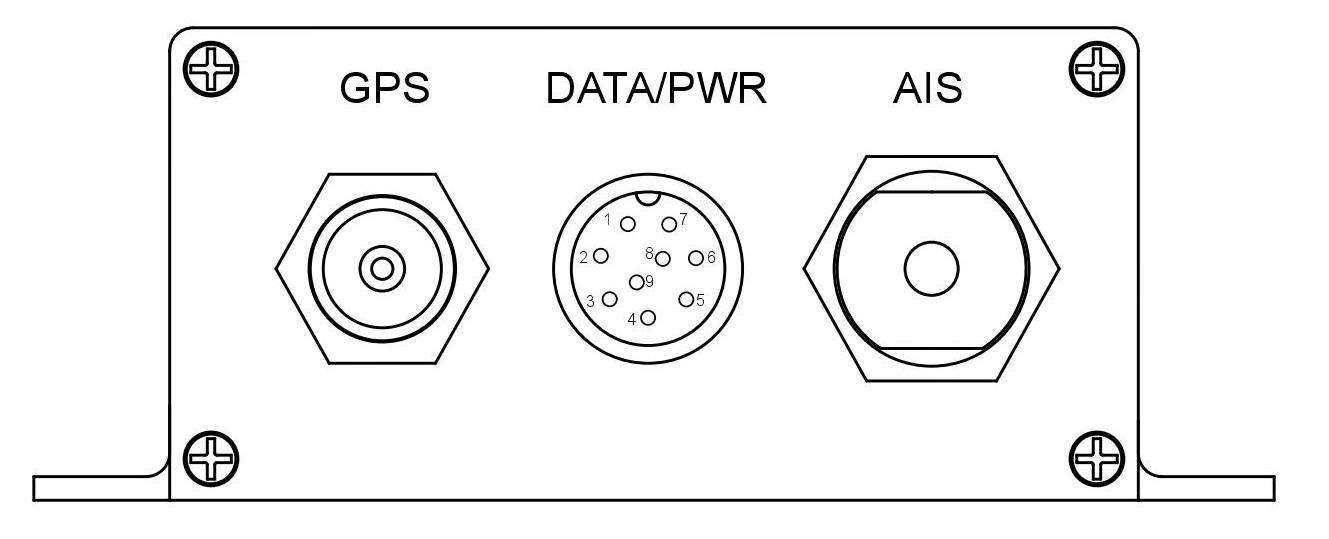
- VHF connector port: Standard SO239/UHF Female connector. Connects to an external VHF/AIS antenna (requires standard PL-259/UHF Male Plug)
- GPS connector: TNC female bulkhead connector for connection to an external GPS antenna. The A051T includes a built in GPS module and only requires a GPS antenna to be connected
- POWER connector: 9 pin POWER/NMEA connector
- POWER supply range: 12V – 35V
- 2 NMEA 0183 output ports (1x RS422 and 1x RS232): For connection to chart plotters and other NMEA0183 compatible equipment as desired.
- USB output: Type B USB for easy connecting to your laptop or PC (Data viewing and configuration when required, Please note, initial configuration may only be performed using a Windows operating system.)
- WiFi Output: The NMEA 0183 sentences are also transmitted through WiFi. It support Ad-hoc and Station mode WiFi (with and without a router). No configuration required for Ad-hoc WiFi.
- LED lights confirm incoming and outgoing AIS messages, GPS, WiFi and Power

Find out whether you need a Class A or Class B transponder here.
Perfect for use in all Class B boats (under 300 tonnes etc.): sailing boats or yachts, small fishing boats, etc..
.
Easy to install and use…
Step 1 – Decide where to put your transponder on your boat
A key advantage of this Class B Transceiver is that we’ve encased it in aluminum – to minimize interference from other equipment. This opens up many more places you can install the A051T, compared to most other transponders.
.
Step 2 – Choose your power source
The A051T Class B Transponder can be powered by a power supply ranging from 12v to 24v. This covers most power sources used on boats, and is a distinct advantage over transponders that are powered only by a 12v power supply.
.
Step 3 – What do you want to see?
The Class B Transponder will of course broadcast your location – but in addition it also receives AIS signals from other ships in your area and receives your GPS location.
Your A051T transponder has input ports where you simply connect your aerials.
You will need to install two aerials:
- A VHF antenna – to collect and transmit the AIS data
- (If you want to use the same VHF aerial as your radio communication, simply use a splitter before connection.)
- A GPS antenna – used to pinpoint your accuate location
.
Step 4 – Transmitting your location (ON/OFF)
As this is a Class B transponder, you can decide when (or if) you want to transmit your location, using STANDBY mode in the Configuration software.
.

Step 5 –Which screen/s will you connect your A051T transponder to:
- Chart plotter NMEA 0183 RS422
- Chart plotter NMEA 0183 RS232
- Windows or Linux laptop (using the USB input or WiFi)
- Up to 4 wireless devices (phones, tablets or laptops) in Ad-hoc mode WiFi
- Wireless devices through your Access point/router in Station mode Wifi
This Transponder works in both WiFi modes, Ad-hoc and Station modes:

.
Who will be able to see my transmitted AIS signal?
Nearby ships will be able to view your details using their AIS receiver, even in bad weather and poor visibility.
Around the world, AIS data from most ports, coastlines and internal waterways is uploaded to the internet by the local community. This means that, if you are in one of these areas; your teammates, partners and loved ones will be able to view your location, using one of the free online AIS websites, from anywhere in the world.
Whether for peace of mind or project tracking, this can be very useful. Find out more here.
.
What’s included?
- 1 x A051T AIS Transponder (class B)
- 1x WiFi antenna
- 1 x 9 pin POWER/NMEA cable
- 1 x USB cable
Available to add to your order:
.
IMPORTANT: Class B Transponder
AIS transponders themselves don’t need to be registered, however, each requires a unique and official 9-digit Maritime Mobile Service Identity (MMSI) number assigned to the vessel and its owner.
To obtain an MMSI number, you should contact the relevant authority in your country. Different countries have different authorities responsible for this service. If you are not sure, search ‘how to apply for an MMSI in (country name)’
Please Note: The QK-A051T Transponder will allow you input an MMSI number only once.
Please make sure you input the correct MMSI number before clicking ‘config’, as changes are not permitted after confirming.
Help and Support
For any technical questions regarding this product, you can visit the forum at https://www.quark-elec.com/forum/ and ask us your question, it’s regularly checked by our technical team and your question may already have been answered there.
Alternatively, contact us directly, with details of your set up and we will be happy to help.
Manual / Drivers
..
Setup Guide
QK-A051T Basic Setup Overview.
![]()
..
Manual
Detailed technical specifications. (The ‘Technical Application Note’).
![]()
.
Drivers
The QK-A051T comes preloaded with drivers.
The driver may automatically install to your device running Windows 10. If not, or you are using an older Windows system, the driver is on the CD provided and as a free download here.
![]()
.
Configuration Software
The configuration software is for configuring the A051T.
![]()
Technical Info
Technical Specifications
- Standard IEC 62287,ITU-RM.1371,IEC 60945, IEC 61162
- NMEA OUT 1 NMEA 0183 RS422 -38400 bps
- NMEA OUT 2 NMEA 0183 RS232 -38400 bps
- Sensitivity -109 dBm
- Power 2W
- Channel A CH87B(161.975MHz)
- Channel B CH88B(162.025MHz)
- Input Level 12V-24V
- Transmit Mode CSTDMA
- Bandwidth 25 KHz
- Bit ratio 9600 bps
- Consumption < 4 W
Environmental Factors
- Working Temperature -15℃~55℃
- Store Temperature -25℃~70℃
- Humidity 0~95% RH at 40℃
- Water resistance IPx2

.
AIS classes
There are two classes of AIS unit fitted to vessels, For more detailed explanation read the manual.
Class A ship messages reporting intervals
- Ship at anchor or moored 3 min
- Ship 0-14 Knots 10 sec
- Ship 0-14 Knots and changing course 3.3 sec
- Ship 14-23 Knots 6 sec
- Ship 14-23 Knots and changing course 2 sec
- Ship > 23 Knots 2 sec
- Ship > 23 Knots and changing course 2 sec
- Ships Static Information 6 min
A Class B unit will transmit its MMSI, Call Sign and Name, length and beam, ship type, time, course over ground (COG), speed over ground (SOG).
.
Class B ship messages reporting intervals
- Ship with Speed Over the Ground < 2 Knots 3 min
- Ship with Speed Over the Ground > 2 Knots 30 sec
- Ships Static Information 6 min
Pre-configuration service
If you order the Pre-configuration service we will pre-configure your transponder with your MMSI number, ship type and any other required information (Particularly useful for customers who do not have access to a Windows system).
NOTE: Some of this information is required by law for CLASS B transponders. The customer is responsible to check what other fields are required in their location.
The minimum information we require is the MMSI number and ship type (Any un-required fields can be left blank).
.
The following data can be pre-configured, if specified.
MMSI – The Maritime Mobile Service Identity number is your unique 9 digit number that is assigned to a DSC (Digital Selective Calling) radio or a transponder unit. See chapter in manual on Mobile Maritime Service Identity.
Ship type – This field should contain a number referring to the type of vessel you are using this transponder on. For example ‘36’ for vessels using sail propulsion. And ‘37’ for pleasure craft (Yacht powered by engine).
[lgc_column grid=”70″ tablet_grid=”70″ mobile_grid=”100″ last=”false”]
GPS (A, B, C, D)
A: Distance from bow to GPS antenna in metres
B: Distance from stern to GPS antenna in metres
C: Distance from port to GPS antenna in metres
D: Distance from Starboard to GPS antenna in metres
(The transponder must know where your GPS antenna is located to make accurate readings.
Be as accurate as possible when writing this information as it will impact on the accuracy of your GPS data.)
[/lgc_column]
[lgc_column grid=”30″ tablet_grid=”30″ mobile_grid=”100″ last=”false”] [/lgc_column]
IMO – International Maritime Organization number should be entered into this section, if relevant. This can be found on the hull and certificates for the ship.
CALL SIGN – Your vessel’s call sign if relevant.
Draught – The vertical distance between the waterline and the bottom of the hull (keel), with the thickness of the hull included. Draft determines the minimum depth of water a ship or boat can safely navigate.
Name – Name of your vessel.
Message us your required information, either on the order page or via email to info@quark-elec.com.
For your security, ensure you email us from the same email address as you entered in your order.
AIS Receiver comparison guide
For mobile view and PDF click here
| Features | A021 | A024/026 | A026+ | A027 | A027+ | A028 | A051 | |
 |  | |||||||
| Description | Function | Entry level AIS Single channel auto-hopping USB dongle | Dual channel AIS receiver (+GPS in A026) Combines AIS (+GPS) and NMEA 0183 input Outputs WiFi, USB and NMEA 0183 | QK-A026-plus NMEA 2000 AIS Receiver with NMEA Multiplexer+N2K Converter + WiFi + GPS Outputs to USB/WiFi/NMEA 0183/NMEA 2000 | Dual channel AIS+GPS receiver, with SeaTalkTM to NMEA converter Combines AIS, GPS and SeaTalkTM input Outputs WiFi, USB and NMEA 0183 | QK-A027-plus NMEA 2000 AIS + GPS receiver with NMEA multiplexer and ethernet Outputs Ethernet, Wifi, N2K, USB | NMEA 2000 AIS receiver + GPS Outputs USB, NMEA 0183 and NMEA 2000 | WiFi AIS Transponder Class B Outputs WiFi, USB and 2 x NMEA 0183 |
| INPUT connections | AIS dual channel | ✓ | ✓ | ✓ | ✓ | ✓ | ✓ | |
| AIS channel hopping. (A single channel receiver that ‘hops’ between two AIS channels)[1] | ✓ | |||||||
| AIS sensitivity (@30% PER) | -104dBm | -105dBm | -112dBm | -104dBm | -112dBm | -105dBm | -109dBm | |
| AIS range[2] up to... | 12nm | 22nm | 50nm | 20nm | 50nm | 20nm | 40nm | |
| AIS antenna connection | SMA (+BNC adaptor) | BNC | SO239 | BNC | SO239 | BNC | SO239 | |
| NMEA 0183 input | ✓ | ✓ | ✓ | |||||
| SeaTalkTM bus input (SeaTalk converting) | ✓ | ✓ | ✓ | |||||
| GPS module integrated (requires GPS antenna) | ✓ SMA (A026 only) | ✓ | ✓ SMA | ✓ | ✓ SMA | ✓ TNC |
||
| Power source | Powered through | USB | USB | 12V - 15V | SeaTalkTM bus (12V) | 12V - 15V | N2K bus (12V) | 12V - 35V |
| Multiplexing | Multiplexing | ✓ (A024) AIS+NMEA (A026) AIS+GPS+NMEA | ✓ AIS+GPS+SeaTalk+NMEA 0183 | ✓ AIS+GPS+SeaTalk | ✓ AIS+GPS+SeaTalk+NMEA 0183 | ✓ AIS and GPS | ||
| OUTPUT connections | USB NMEA 0183 output | ✓ | ✓ | ✓ | ✓ | ✓ | ✓ | ✓ |
| NMEA 0183 output (RS422) | ✓ | ✓ | ✓ | ✓ | ✓ | ✓x2 RS422 + RS232 |
||
| NMEA 2000 network | ✓ | ✓ | ✓ | |||||
| Ethernet | ✓ | |||||||
| WiFi | Ad-hoc and Station modes | ✓ | ✓ | ✓ | ✓ | ✓ | ||
| Option to disable WiFi | ✓ | ✓ | ✓ | ✓ | ||||
| Configuration | Configuration through USB port. Configuration requires Windows PC | ✓ | ✓ | ✓ | ✓ | ✓ | not required | ✓ |
| Compatible devices and software | Windows/Mac/Linux through USB | ✓ | ✓ | ✓ | ✓ | ✓ | ✓ | ✓ |
| Chart Plotters | ✓ | ✓ | ✓ | ✓ | ✓ | ✓ | ||
| Android/iOS | USB OTG | WiFi | WiFi | WiFi | WiFi | WiFi | ||
| [1] Manually adjustable hopping interval rates (0.25 seconds, 1 second, 30 seconds and auto-hopping) Channel hopping will increase the number of messages received, in comparison with single channel receivers. However, part of some multi-AIS messages may be lost, due to the hopping nature of the product. If both the quantity and the completeness of AIS messages is important to you, we recommend the dual channel receivers. [2] Mounted on a masthead, 20 feet above sea level. * SeaTalk™ is a registered trademark of Raymarine. |
||||||||
You may also like…
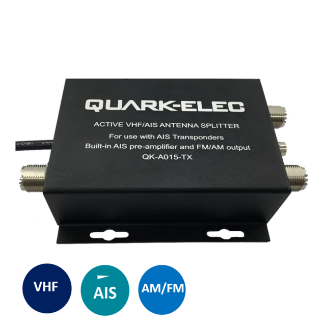
QK-A015-TX Active VHF Splitter (for AIS transponders)
$273.72 ($228.10 excl. VAT)